Sunday 17 October 2021

Queens Park residents urge UK and world governments to take urgent action at COP26


Brent Friends of the Earth took their stall to Queens Park today and set up outside the Farmers' Market at Salusbury Primary School.

Children and adults answered the call to send messages to the Government and the Conference on the need for urgent action to address the climate emergency.

The messages have been recorded and the pennants left hanging on the school railings for pupils, parent and staff to see tomorrow morning.

Friday 15 October 2021

Harrow and Barnet Council face up to the flood challenge - will Brent follow?


Wembley Matters has recently been focusing on the potential impact of severe weather events on potential flooding in the north LINK and south LINK of the borough so it is welcome to hear that neighbouring boroughs Harrow and Barnet are taking action on the Silk Stream catchment that feeds into the Welsh Harp.  Without mitigation torrential rainfall carried by the Silk Stream could have a major impact on the Welsh Harp and lead to the opening of sluices at the dam with the excess water flowing down the River Brent.


This is Thames21 account of the project and consultation:

A major six-year partnership project will work with nature to reduce the risk of flooding in the Silk Stream catchment and wider River Brent.


The Silk Stream Flood and Resilience Innovation (SSFRI)  is a partnership project, led by Harrow and Barnet Councils with involvement from Thames21, Thames Water, Environment Agency, Greater London Authority, Canal and River Trust, Brent Catchment Partnership, Friends of the Silk Stream Resident Group, Silk Stream Flood Action Group and others. The project is funded by the government’s Flood and Coastal Resilience Innovation initiative and is one of 25 related schemes across England.


The project will explore opportunities to build new wetlands, restore stretches of river and create new areas of natural drainage to increase flood resilience as well as create a host of other benefits, including improved water quality, beautiful public spaces that will boost health and wellbeing and much needed habitat for wildlife.


We need your help!


Please fill in our online survey to share your knowledge of the catchment and your ideas about how the project should develop.


To be successful we need the knowledge and insight of local people. Throughout the project there will be multiple opportunities for local people to help shape project proposals. We’ll also be creating opportunities to learn more about rivers and the wildlife they support and to get actively involved in improving rivers and building flood resilience. To find out more about our plans and how you can get involved and influence what we do, use the link below to add yourself to the project mailing list.


Join the SSFRI mailing list.


The Silk Stream Catchment


The Silk Stream is a major tributary of the River Brent, rising on the Harrow Weald and Barnet Plateau and joining the Brent at the Welsh Harp Reservoir. It has several tributaries including Burnt Oak Brook and Edgware Brook. The Silk Stream is an important resource for wildlife and, along with Burnt Oak Brook, is designated a Site of Importance for Nature Conservation. Welsh Harp Reservoir where the Silk Stream meets the Brent is a Site of Special Scientific Interest due to the diversity of breeding water birds that it supports.


Flooding is a serious concern in the catchment and it’s estimated that over 1000 properties are at risk. As the catchment has become increasingly urbanised with natural vegetation replaced by hard surfaces, water is less able to soak into the ground and during intense rainfall events water levels can rise rapidly, causing flooding.


Pollution is another problem that affects the Silk Stream, coming from a variety of sources including plumbing misconnections and connectivity between the surface water and foul sewers. During high rainfall events the sewers reach capacity and these problems are intensified.

How will the project help?

Traditional approaches to managing flood risk have focused on concrete flood defences but there is a growing movement towards natural flood management (NFM) which works with nature to slow the flow of water entering rivers, create natural flood storage and reconnect rivers to their flood plains.

The project will see the creation of new wetlands in several parks in the Silk Stream catchment which will help build flood resilience, improve water quality, boost biodiversity and provide valuable blue/green spaces for people to enjoy.

Sustainable Urban Drainage Systems (SUDS) such as rain gardens will be created in the urban streetscape to help remove pollutants from road run-off and slow the flow of water entering the surface water sewer system.

The project will also enlist the help of Thames Water, using innovative ‘thermosensors’ to discover where surface water is entering the foul network as part of efforts to address sewer flooding and the serious issues pollution that affect the catchment.

By using a variety of solutions and looking at the catchment as a whole the project will create tangible environmental benefits and allow for learning that can help replicate these benefits across the broader Brent Catchment and beyond.

Get involved

Contact us at silkstream@thames21.org.uk if you have any questions to find out how you can get involved.


Thursday 14 October 2021

Come to Queens Park Farmers' Market on Sunday and send your message to COP26 - Tulip Siddiq MP has sent hers in advance

Children's messages at the Harlesden stall


Brent Friends of the Earth will be setting up their 'Messages for COP26' stall outside the Farmers' Market at Salusbury Primary School, Salusbury Road, Queens Park on Sunday from 11am to 1pm. 

This is the third stall after successful appearances in Harlesden and Wembley Central.  The pennats will be displayed outside the school before being sent to the politicians and NGOs  in Glasgow.


Hampstead and Kilburn MP has sent  her pennant in advance.


Paper and pens are all supplied  so pause for a few minutes to send a message, which along with thousands of others,  may save our children's future.


Wednesday 13 October 2021

After the July floods urgent action needed on the depleted flood defences of South Kilburn as densification continues - Guest Post


 Cambridge Gardens, Kilburn July 2021 (Kilburn Times)


The Westbourne 1790


 The culverted Westbourne

Sign in the former Bird In Hand Pub, West End Lane
 

Guest blog by David Walton of FLASK (Flood Local Action South Kilburn. The views expressed are those of the author.


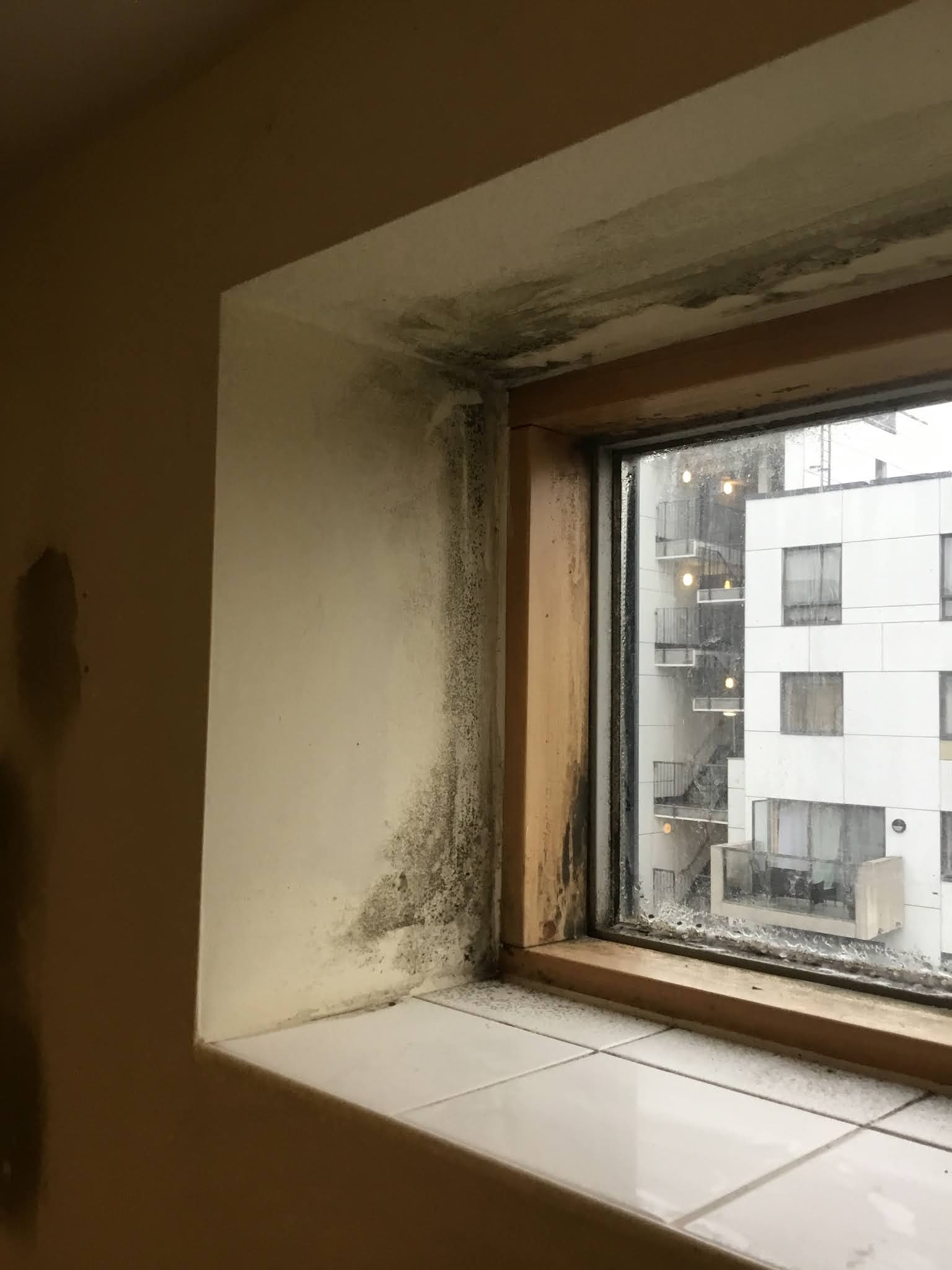
The raw sewage river flooding 'major incident' of July 2021 in  South Kilburn and North Westminster, has meant that scores of residents are still housed in temporary accommodation, claims are being made and homes are being dried-out and repaired. Why did this happened? Who pays now and for future major floods?

Householders should beware that new experiments, regressions, crisis and disruptions  are being knowingly allowed in specific new city zonings. In starting to examine this 'major incident' covering Environment Agency policies, unsound growth area, tall buildings, very large site zonings, local flood authority responsibilities, planning law and emergency planning,  a complex picture of government and political indifference  emerges with baked-in environment/ climate denial in regard to the South Kilburn Estate version of 'build back better' where five times the number of homes it had in the year 2000 are being towered, forced and packed onto the River Westbourne's flood plain by year 2041.

The key strategic decision change seems to have been around 20 years ago when the Environment Agency chose, as does the Greater London Authority and Brent Council, that developers could totally deny the existence of the River Westbourne and its tributaries running underneath South Kilburn. Note that South Kilburn's river delta shape is still apparent today and also how early nineteenth century maps of South Kilburn show these rivers set in dairy farm fields, rivers which though in culverts for over 100 years now are natural and still very much here, live and ever present however much denied by government, agencies and politicians.

Taking the Environment Agencies lead and despite all too apparent on site water facts, for Brent Local Flood Authority the River Westbourne and its tributaries simply do not exist anymore (see clause 6.55 Brent Strategic Flood Risk Assessment 2007). A Strategic Flood Risk Assessment process is meant in law to be a 'live' document yet seems to have been rather abandoned at Brent Civic Centre. How 'live' these rivers become in the major incident investigation of 2021 for South Kilburn 'very large site' will be public knowledge soon.

For example, of neighbouring local authorities: Kensington and Chelsea Strategic Flood Risk Assessment highlights the River Westbourne as its second major flood risk after the River Thames and marks the entire river course and tributaries from Hampstead Heath down to the Thames at Chelsea. Camden Strategic Flood Risk Assessment map helpfully indicates historic flooding of South Kilburn and maps how the south west of Camden drains down into South Kilburn vale in Brent. The City of Westminster Strategic Flood Risk Assessment map helpfully indicates historic flooding of Chippenham Gardens, South Kilburn located north of the Westminster boundary.

Since first being built on in the mid nineteenth century South Kilburn was notorious for its flood risk to homes and this kept the area unpopular with new houses being difficult to sell and poverty  concentrated there. This memory of urban trauma inspired progressive architects and planners post World War 2 to protect and transform this flood risk and literally bad land by building a new public owned estate of housing for 6,000 people, with social and health infrastructure set in an impressive recreational parkland of public owned flood defences where flood water could stand, pool and be absorbed by woodland environments naturally- a major London success much celebrated at that time.


The protection/ sustainability long-term problem for this massive public investment however was that all public owned estate community new diverse specific land uses were and remain unregistered at the UK Land Registry and later 1970's phase built large panel blocks were unmortgageable as they had catastrophic build defects baked-in.


From year 2010 the South Kilburn Growth Area with its green parkland public flood defences total removal policies and resultant ever increased flood risk being manufactured, led to a deal being struck with Westminster. The then City of Westminster Plan highlighted the South Kilburn Growth Area policy as being a major risk to its residents. 


So, to protect Maida Vale/ North Westminster in 2015 a £17.5 million flood defence mitigation scheme was built by Thames Water in the form of two large underground rivers flood sewage storage reservoirs sited within North Westminster. However, July 2021, one month’s worth of rain fell in one hour and the River Westbourne and its tributaries sewage waters rose above ground on to streets and flowed into ever reduced flood protections South Kilburn and then horror on into £17.5 million extra flood protection designed North Westminster homes as well! South Kilburn is become a sinking sink and is now proof positive that rivers sewage flood risk, crisis impact and misery can't be neatly corporate zoned in by design anymore.


Government responsibility finally has to be taken and the River Westbourne and its tributaries need to be recognised as existing acknowledged as a real problem again for politicians, public servants, shell company freeholders and developers. Often already off-shored and hard to trace new owners of South Kilburn enclosures/ towers built on former public owned flood defences already will certainly not accept responsibility for the massive costs involved in totally predictable and accelerating future major flood incidents. After all the Environment Agency ‘disappeared’ the River Westbourne and its tributaries in South Kilburn, so that is the current 'live' get out of jail free card/loophole still in place legally for South Kilburn developers. Instead help-to-buy and affordable rent families will have to pay government backed massive repairs loans and forced to pay increased charges. The parallels here with the ongoing inflammable building materials crisis facing leaseholders and tenants since the Grenfell fire disaster are remarkable - a predatory political forward strategy of government by debt in South Kilburn tall building zone? Build back inflammable, build back no health and social wellbeing infrastructure to be retained and build back wetter!


Granville New Homes was built on Granville Road Public Open Space which was designed  as a major South Kilburn flood defence and Higgins are building at Chippenham Gardens in 2021, taking part of another flood fence open space.


The positive news October 2021 is that half of South Kilburn’s public owned green flood defences still exist and function (hence not all of South Kilburn was flooded), even though in parallel they are also Brent 'site allocations' in the unsound as proposed Brent Local Plan towards 2041 (where flood defences are all to be denied and total destroyed). Strong legal protection of the remaining flood defence system for South Kilburn is still possible, while flood defences already market destroyed can and should be urgently restored to raise flood protection back to where it was back in year 2000 as the humane bare minimum. What is the massive Community Infrastructure Levy already raised inside South Kilburn from private developers for if not also to reduce rather than grow multiple deprivations for people living in this zoned experiment in mega population density?

Monday 11 October 2021

More shocking pictures of the state of the Higgins built Granville New Homes


Cllr McLennan claims that a Granville New Homes situation would not occur today as Council has improved procurement procedures and would not tolerate such poor workmanship

 Recording of the Granville New Homes item at Cabinet this morning.


Cllr Margaret McLennan, Deputy Leader of Brent Coucil and lead on Finance, told colleagues at today's Brent Council Cabinet that the poor build of the Granville New Homes back in 2009 would not happen today because the council has improved robust procurement procedures in place and the present council   would not tolerate such poor workmanship.


McLennan did not directly address the fact that the project was built by Higgins who are currently building for the council in Stonebridge, but at the same time said that the recommendations from Scrutiny were 'pertinent and valid' and would ensure that such an issue would not occur again. LINK


However Scrutiny's recommendations were not put to a formal Cabinet vote so their status is unclear.


Cabinet agreed to transfer 84 social housing units to the Housing Revenue Account  and 25 intermediate units to i4B and refinance the debt after consultation with those residents involved. Details of the consultation were not given, nor consideration of what would happen if they did not agree with the option the council put forward.


Cllr McLennan said that financial issues aside the first and foremost concern of the Council was to make sure tenants were safe. 


It is worth noting that in 2019 in a guest post on Wembley Matters, Pete Firmin raised issues about building quality in another South Kilburn development LINK illustrated with this photograph.


The voice of a far from happy Granville New Homes resident

 These are the questions that a Granville New Homes residentr was unable to put to Scrutiny Committee.  I felt it important to publish them to counter the claim that the residents are happy.


These are the following bullet points that I would like Brent Council to answer..
* why were we robbed of the property that was promised to us when the first regeneration was taken place and told that the property that was shown to us was what we viewed in the first place ( first lie ).
* why were we  lied to in the past that is still continuing  up to the present date.
* why were we shown a derelict property in order to  force us to move.
* why were we not  one of the first tenants be rehoused and left to the last and still awaiting 
* why has seven different housing office discussed moving then vanished
* why have all our complaints been ignored
* why were we threaten to be thrown out on the streets
* why was a eviction  notice served by Brent 
* why were we being bullied 
* why have we got seven fire alarm in the property that are faulty of late
* why are we constantly being  threaten to be taken to court and were taken to court.
* why are we forced to live in a property that is a danger to our health 
* why are we being forced to leave the area as it has clearly been stated the reason why we should remain in the area 
* why has Brent not  recognised the stress that these actions has caused and is still ongoing
* why have certain members of Brent staff  proved to be untrustworthy 
* why is a certain member of Brent staff blocking the process of us being moved
* And the list goes on these are a few things that I would like to be resolved

The resident has sent photographs (below) of the state of the building - built in 2009 for £17.5m.


Sunday 10 October 2021

Fill in this survey if you want to see improved public toilet facilities in London

 Public toilet in Wembley Park


London is open - but what about its toilets? There are just 3 weeks left to complete this important survey on public toilet provision. The survey is part of the London Assembly Health Committee’s investigation on Access to public toilets 


Public toilets in London - Introduction

The London Assembly represents the interests of Londoners and holds the Mayor to account. Your opinions will help the London Assembly with its research. We can share your experiences and inform the Mayor of your views on public toilets in London. This survey will be included in a report which we hope will provide a snapshot of public toilet provision in London and inform us about what needs to happen next.

By ‘public toilet’, we mean any toilet that is publicly accessible. This could be a toilet run by a local council (in a park, for example), a toilet available to use in a public building such as a library, or toilets in a privately run space but available to any member of the public, such as a shopping centre. Also included are toilets in places such as cafés and shops when they are part of a scheme (such as a Community Toilet Scheme) which means they are specifically open to non-customers (i.e. you don’t have to purchase something to use the toilet).

You don’t have to answer all the questions if you don’t feel like it. Here’s what this survey is about:

 
In part 1, we’re asking some questions to understand your experiences of using public toilets in London.
In part 2, we’d like to know a little bit about you.
It will take 10-15 minutes to complete.


The details...
All responses will be treated confidentially. Answers will be grouped together, and no individual will be identified in any publications.

The GDPR bit...
You are in control of any personal data that you have provided to us in your response. You can contact us at any time to have your information changed or deleted. Please contact  daniel.tattersall@london.gov.uk.

We are undertaking this survey to aid the London Assembly to support and represent Londoners.


https://survey.alchemer.eu/s3/90382235/Public-toilets-in-London