Showing posts with label South Kilburn. Show all posts

Tuesday 22 March 2022

South Kilburn residents will have to endure a summer of 24 hours a day, 5 days a week, work on the HS2 vent. Is Brent Council concerned for their health and wellbeing?


Seven years ago South Kilburn residents demonstrated against the siting of an HS2 vent on the estate because of the disruption its building would cause and the fact that it was right next to a primary school.

They were even more furious when they discovered that their own council, Brent Council, had lobbied to have the vent moved to the estate, already suffering from disruptive regeneration, from the original site on council owned land next to Queens Park station.

Years of noise, dust and stress have followed so residents were even more distressed to have a warning from HS2  LINK of worse to come.  South Kilburn resident Pete Firmin told Wembley Matters:

HS2 seems to be able to work whenever it likes, doing whatever it wants, with the blessing of Brent Council. The Council itself never communicates with local residents about the works, and as far as anyone can tell, doesn't monitor whether HS2 keeps to even the few restrictions on its working hours etc. Neighbours of the vent shaft have given up complaining, because nothing happens. How inadequate protection from noise and dust really is may be indicated by the fact that HS2 lists further work on the retaining wall they already erected between the site and Carlton House as one of its next jobs. 


Since persuading HS2 that the vent shaft should be in the middle of the estate rather than on the empty Queens Park station car park, Brent, for all intents and purposes, has washed its hands of any responsibility. And HS2 is no longer willing to meet residents together, insisting all "consultation" is one to one.


No recognition by either Brent or HS2 of the stress and exposure to noise and dust caused by living in the South Kilburn building site for 20+ years

This is part of the communication from HS2 to residents:

Extended working hours within the Canterbury Works site

 
We wrote to you previously regarding extended hours while we build the ventilation shaft. The sprayed concrete lining (SCL) works were due to start on the 7 March 2022 and continue until September 2022.due to ongoing reviews of our working methods, these works work will now start in late March or early April and will continue until September 2022. The exact date remains subject to confirmation.

The SCL and shaft excavation works will take place throughout the day and night. This must be carried out as a continuous process to avoid collapses and ensure the safety of the workforce within the ventilation shaft during construction. This means that from late March / early April we will be permitted to carry out works 24 hours a day, 5 days a week. We will only carry out works agreed with Brent Council and will adhere to the agreed working hours, noise and vibration limits.

The diagram below shows a cut section of the shaft and how it will be constructed.

Enhancement works within the Network Rail Yard

 
Works are ongoing within the site, near the Network Rail tracks, to prepare for installation of a new site access point via Albert Road. These works will involve the construction of a new access ramp for vehicles to enter the site. As part of these works, we will be carrying out works to strengthen the retaining wall between our site and back gardens at Carlton House. These works are currently planned from May to July but remain subject to confirmation. The works will be agreed with Brent Council and we will write to Carlton House resident with more information.


Whilst we continue the works to prepare for the new ramp and vehicle access point, we will continue using the site access on Canterbury Road for vehicle entry and exit from site.

What to expect during our works

 
During the works outlined in this update you may notice the following within the site:
• Heavy good vehicles – entering and exiting site
• Excavators / excavating activities
• Cranes / lifting operations
• Lighting towers
• Concreting equipment
• Temporary traffic management and signage during work on the public highway


Monday 21 March 2022

Densification along with misleading figures on community space and green space provide ammunition for South Kilburn residents to fight for a better deal


As tables were being cleared after the usual community meal at the Granville Centre in South Kilburn, Leslie Barson  of Granville Kitcheh stepped forward to introduce the evening's rather special speaker.

 She said, 'I have been thinking - you can't have a project without a place to do it. And you need a project for the place.'

The Granville and Carlton Centres have done so much, so many projects, over the Coviud crisis and proved its essential role in the community along with Rumi's Cave (now relocated in Harlesden) and had kept people together: 'We now understand its relevance.'

The planning application approved at the beginning of 2020 is to be actioned over the next few months.

Dr Pablo Sendra from UCL who had led the research project 'Co-designing social infrastructure for resilient communities in post-Covid cities' addressed the crowded room full of local residents. A rare collaborative effort between community and academics.

In his talk Pablo made a number of key points:

Researchers estimated that the Granville Centre over 65 weeks had provided £344,760 worth of volunteer labour,

Quoting the Mayor of London that organisations, projects and buildings need to be more connected and relevant he asked, 'How can the community be more involved in how the building and its spaces work?'

As a result of regeneration South Kilburn had increased in density and needed more community spaces. The 'Community Hubs' hailed by the Council were places to ask the Council for support, rather than for organising activity. Bland spaces were being provided that people did not feel comfortable in. [Later I mentioned the 1970s 510 community centre in the Harrow Road with its old settees and arm chairs, kettle in the corner, that people treated as home from home and housing many organisations involved in anti-racism, immigration, education and campaigns against SuS.]

The former hall in the Granville where people used to meet has been converted into an 'enterprise space' . Overall the research showed that the Council estimate of a overall loss of  community space of 5% had not included the Granville, Carlton and Rumi's and in fact the loss was 60%.

The workspaces were rigid, enclosed office spaces but the UCL survey showed that people wanted much more creative spaces for activities such as pottery and music.  At a time when people were used to working from home the space offered had to be more than a desk and internet - otherwise people would continue to work from home.

Green spaces were also important. Brent has a very low ratio of green space per person and regeneration will decrease the amount of green space.  And of course densification is going to increase the population significantly. During the pandemic green space became an important outdoor safe space for mental and physical health as well as a place to catch up with neighbours.  It also lent itself to food production and community gardening.

Summarising the recommendations (full details below) Dr Pablo Sendra listed:

1. No loss of community space

2. Creative and well-equipped workspaces

3. Address potential conflict between users (quiet activities versus noisy or messy)

4. Welcoming space to socialise

5. Diverse types of community spaces

6. Spaces for emotional support

7. Activities for young people

8. Flexible and well-equipped green space

9. Local food production and gardening

10. Inclusive process for decision making

11. Involvement of the community in the running of the buildings

12. Work on a resilient funding model.

In discussion questions were asked about the possibility of legal action against Brent Council over its decisions in the light of the research findings. whether the council had carried out a lawful consultation and how the council's action stood regarding the Equality Act.

Asked what next Pablo said that it was now a matter for the community to mobilise itself using the research findings to ensure that they maintained, managed and improved the good space that they had.

After the meeting Leslie Barson said:

Granville Community Kitchen is  very pleased to have this research that identifies and clarifies what needs to be done and why to safeguard The Granville and The Carlton as multi purpose community spaces. We hope the Council will find it useful too and help the South Kilburn community achieve the report's recommendations.

Pete Firmin, a local resident, queried:

When Brent says there has been little loss of green space with regeneration in South Kilburn, I wonder whether they take account of the fact that much of the green space previously was open to all, yet now much of such space is reserved for residents of certain blocks. And green space now is more more patchwork - many smaller spaces, rather than larger ones which allow for ball games etc.


The report implies that the Granville/Carlton Centres, whatever else is going on there, are under community control. They never have been and are not now. They are under the control of Council-appointed bodies, with South Kilburn residents having very limited say in their use.


Monday 7 February 2022

Camden and Brent agree redesignation of the Kilburn Neighbourhood Forum

 Following consideration of responses, both Brent and Camden Councils approved the application to re-designate the Kilburn Neighbourhood Forum.

This means the Kilburn Neighbourhood Forum will be able to continue the preparation of a neighbourhood plan in their area. 

South Kilburn is not included in the Forum.

Consultation responses can be found HERE


Wednesday 2 February 2022

Observations on South Kilburn in the light of the Brent Local Plan

 Guest post by David Walton of FLASK

The new proposed Brent Local Plan to year 2041 is set to be put for adoption to Full Council on 24th February 2022.


Government Planning Inspectors in January 2022 put forward their final report and modifications to Brent Council. Here are some South Kilburn (soon to be Tall Building Zone (?) local observations…….


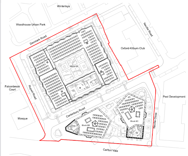
South Kilburn Growth Area, South East Place (one of 7 large often internally un-related and un-relatable Brent Plan 'places') is excluded from being part of Kilburn Neighbourhood Forum Plan for Kilburn Town (Kilburn electoral ward), but is where Kilburn Town (Kilburn electoral ward) will tower and excluded mega population grow - a bit like Wembley non City, a bizarre, colonial and fractured approach to Brent’s major change.


It is of note that these modifications that all site allocation insert plans for South Kilburn have been removed by inspectors from this new Brent Local Plan. I suppose that is one solution to resident questions, but this future engagement is unhelpful as South Kilburn has so many 'site allocations' (knowns and unknowns) pending which must now rely (unlike for other Brent places) entirely on words. Some title headings for new sites have had modifications removed- why not keep a plan saying that current state school land uses or public open space land uses are become new 'site allocation' opportunities instead?


It is also worth noting that many South Kilburn large 'sites' don’t even make this modified plan, for example the Cullen House/ station car park ( long land banked), new Peel Square with its 16 storey Countryside tower yet to be built,  Carlton Granville Community and Education Centres, Brent housing plan 'other ideas site' and more….. What are the infrastructure planning requirements for this plan sites denied- none? Should flood alleviation infrastructure and social infrastructure not be stated in Policy BSEGA1 South Kilburn Growth Area? There is certainly a lot less social and health infrastructure required than the 2010 SKGA plan and that was a lot less required than the 2004 Neighbourhood Plan offer (2016 Brent cancelled).


The reality is that South Kilburn's population is being increased 6 fold from 6,000 in year 2000 to 36,000 by 2041 (sites hidden/ 'moveable feast' ambiguities added). Modification here is clearly all about the scale of the South Kilburn Mega Growth being kept carefully under the radar of Brent wider social and public health/ recreation strategic infrastructure investment for massive population growth..


Of the South Kilburn site allocations which Planning Inspectors modifications:


BSESA1 Austin House and public park demolition. South Kilburn Air Management Area (SKAMA) / 'a car free development should be the starting point.' Infrastructure planning requirements- 'Thames Water has indicated that upgrades to the wastewater system are likely to be required.'


'Are likely to be required' is the key get out clause here, as Brent despite social rent housing clearing since 2005 has yet to produce a detailed Flood Risk Assessment for any of its many South Kilburn Masterplan(s) for massed help-to buy/ affordable housing on a flood plateau. As regards future floods baked-in by the corporate risk appetite for removal of all existing public owned natural flood defences with new builds no longer being built at raised level either, South Kilburn people will have to ' learn to live with it?' and with the costs involved.


What is also interesting is that there are so few site social infrastructure planning requirements for new South Kilburn Growth Area, which is surprising given enormous population growth. This makes the new Brent Local Plan an inequalities/ non citizen zones Brent 'Slum Dog Billionaires' policies document towards 2041 as regards South Kilburn. Very much parallel development and as if Grenfell, Windrush and pandemic simply never happened and the planning reform bill had not been cancelled as being ill advised in 2021 either.


The modifications continue…….


BSESA2 Blake Court and public park demolition; SKAMA/ a car free development…. Despite being adjacent to Austin House public park flood defence, no infrastructure planning requirements at all?


BSESA3 Carlton House and Carlton Hall demolition. SKAMA / a car free development….Despite a community hall and public green space attached being demolished- Infrastructure planning requirements - zero according to Inspectors?


BSESA4 Carlton Vale Infant School demolition. SKAKMA/ not car free as next to the Westminster boundary? Inspectors state that vehicle access between Malvern Road and Carlton Vale is 'proposed' to be closed, which is a bizarre planning statement given that vehicles have been closed from Malvern Road to Carlton Vale since the 1960's, this at that time to prevent regular traffic accidents near the schools and central park. Malvern Road is a Brent long established traffic calmed one way street so what is there to propose? Is the intent to open Malvern Road to two way traffic? SKAMA what SKAMA?


A land swap with Wordsworth and Maesfield House demolitions is proposed for this school’s new site when it becomes mono-housing. This school is currently central public park side located.


BSESA5 Craik Court demolition. SKAMA/ car free development. Public green open space with veteran trees and community hall demolished. Infrastructure planning requirements-non?


BSESA6 Crone Court and Zangwill House demolitions. SKAMA/ car free. Public open space loss, yet the only Infrastucture planning requirement – water supply and waste water infrastructure upgrades possibly.


BSESA7 Dickens House and public park demolition. SKAMA/car free. Infrastructure planning requirements water supply and waste water upgrades hopefully.


BSESA8 Hereford House and Exeter Court, play areas demolitions. SKAMA/ car free. 'Development must be consistent with the recommendations of Brent Local Strategic Flood Risk Assessment Level 2' Infratructure planning requirement. Granville Road Public Open Space (see BSESA11) is to be re-located here at this BSESA8 site. Not very helpful that this requirement Inspectors term 'open space' as that will mean fully private enclosed green space thereby rendered useless to the wider community.


BSESA9. The Inspector doesn't dare to even write Kilburn Park Foundation School demolition anymore. The 'site' created by this will be of ambiguous status as for example SKAMA/ car free development is stated. Then Inspectors later say that the demolition site created will be a park, so a new car free park?


This school land use being built on re-locates to Wordsworth and Maesfield sites but also onto the South Kilburn Public Open Space, Brent Kilburns only park sized park, demolishing its bio-diverse veteran tree woodland area no less!


BSESA10 Neville House, public open space and Winterleys demolition. SKAMA/car free. Infrastructure planning requirements- water supply and waste water upgrades possible.


BSESA11 Again, Inspectors dared not name the site which (upgraded and invested in in 2010) is the remains of the once grand scale Granville Road Public Open Space and flood defence. Less 'public open' too this in recent years as Brent Master Developer has been land bank locking it up on and off. SKAMA/car free. Infrastructure planning requirements- waste water upgrades only. So a no public open space replacement is planning required in a flatted  (no gardens) area of public open space deficiency?


BSESA12 Wordsworth., Maesfield and part of South Kilburn Public Open Space. SKAMA/ car free. Infrastructure planning requirements- new school(s) to replace the two school sites being demolished for housing. Water supply and drainage upgrades? There is no planning legal requirement stated by Inspectors to replace the large chunk of South Kilburn Public Open Space veteran tree woodland area that both school(s) sold for housing will be re-built on?


BSESA13 Again Inspectors unhelpfully decided to abandon naming John Ratcliffe House demolition. SKAMA. Infrastructure planning requirements- waste water upgrades only. 


BSESA14 William Dunbar and William Saville House, community hall demolition. SKAMA/ car free housing. Infrastructure planning requirements- water supply and waste upgrades only.


BSESA15 Not site named again, the UK Albanian Muslim Community and Cultural Centre. SKAMA/ car free housing. Infrastructure planning requirements- water and waste water supply upgrades only.


BSESA16 Oxford Kilburn Club demolition. SKAMA/ car free housing.

Infrastructure planning requirements- Replace club either on or off site (elsewhere)? Water supply and waste water upgrade.

After Brent's take, the OK Club took the lion's share of New Deal for Communities government funds (their first project being to employ a professional fundraiser). It will be interesting to finally see if this by community investment of scarce public funds made any sense now when the OK Club now monumentally 'cashes in?'     


To add, please look at Article 4 (1) Directions published by Brent in July 2021 which includes an SK Inset Map with at least some of this site allocations red-line box's colonialist horrors illustrated. Horrors (not mapped in the Planning Inspectors modified Brent Local Plan of Jan 2022), with Brent South Kilburn mono-colonial-overdevelopment zones new plan to build on current land uses such as South Public Open Space woodland, Granville Road Public Open Space, Kilburn Park Foundation School, Carlton Vale Infants School and Dickens Austen Public Open Space. This all comes into effect 1st August 2022.


The term Growth Area from 2010 BLP should not be retained in this new Brent Local Plan 2022 regarding South Kilburn given the new planning bills 2021 suspension. While underground car parks everywhere as separate 'business' opportunities and the doubling highways by Brent in SK zone should also be made public.


Most of the requirements from the 2010 SKGA plan were not landlord actioned and  in the new plan become cancelled requirements. 2022 SKGA South Kilburn plan infrastructure requirements is for flats as literally the only infrastructure and at densities as yet unseen in the UK! Vague Policy BSEGA1 South Kilburn Growth Area is simply not written into later 'site allocations' infrastructure planning requirements or is ambiguously stated, the same for the BSEGA1 new sites not mentioned at all- no infrastructure planning requirements for them no doubt either?

AnonymousA new England-led 'sovereign take back control' South Kilburn for project Global Britain, of high tax take (tax as tribute for simply being allowed to live in the UK third class)- no social, health, shared services towered zones (a social rent estates level and up/ tower, level and up/tower, again and again as of such poor flood area build quality). A zone where no one is or ever can live a full UK citizen's life, rights, health and wellbeing supports and chances- this all by government Global Britain design.

A mega density non place for non citizens is 2041 guaranteed by these Inspectors modifications and residents concerns were not listened to and not respected. This South Kilburn zoned corporate colony for feeding Global Britain Slum Dog Billionaires risk appetite dines on and on- the South Kilburn 'moveable feast'.


David Walton

FLASK (Flood Local Action South Kilburn)


Sunday 16 January 2022

Soaring communal heating bills likely to add to the troubles of residents in Brent's new developments


An article in yesterday's Guardian set alarm bells ringing for people in Brent who are buying or renting some of the new developments that have communal heating.  

LINK

Guardian Money explained:

While households with conventional heating systems have been told they could face 50%-plus increases to gas and electricity bills when the cap is increased on 1 April, people who bought or rent apartments in one of the 17,000 blocks in the UK that rely on communal heating and hot water systems are facing fourfold increases as suppliers pass on the huge wholesale price increases unchecked.

It is thought that up to 500,000 people live in developments where at least some of the heating or hot water is provided by a centrally controlled system, usually administered by the company that manages the estate.

Apartments in these developments are all supplied by a single energy supplier, and because this is classified as a commercial deal rather than domestic supply, the residents have not had bills protected by Ofgem’s price cap.

The article gives the example of a Manchester owner of a two bedroomed flat whose energy bill went up from £80 in November to £260 in December.

Individual occupiers cannot change their energy supplier so will be reliant on the managers of the developments to negotiate a deal. Systems designed to reduce carbon and lower bills may unfortunately prove to be an additional burden to people already facing high service charges and in some cases costs for cladding removal, building defects remediation and fire watches.

The Agenda for a June 2021 meeting of residents in George House, South Kilburn, gives a flavour of the range of issues facing residents at an L&Q development LINK:

Proposed agenda for 22nd June Swift George Residents Association meeting

  1. Clarification/update on works to heating & hot water pipe work (including explanation of recent system outages).
  2. Update on replacing terracotta cladding & issuing of EWS1 form 3 and clarification of fire safety policy
  3. Update on safety of windows following the failure of hinges in another L&Q development (we believe we have the same hinges)
  4. Update on service charge refund (the review Rob Hunter had been carrying out).
  5. Energy meters & billing – energy meters appear not to be working or faulty.
  6. Pigeons – reports received of them nesting on the roof of George House and leaving deposits on the flat roof of the 6th floor
  7. Any Other Business (AOB)

Some of the heating issues may have been resolved see HERE

Wembley Matters would be interested in hearing from residents in the South Kilburn, Wembley Park and Alperton regeneration areas who have communal heating  systems if they have been impacted by higher energy costs.

Thursday 23 December 2021

South Kilburn residents object to high rise redevelopment proposal on the Crone, Craik and Zangwill site


Block A maximum 10 storeys c65metres,  Block B maximum 16 storeys c86metres, Block C maximum 12storeys c72metres.

The proposal:

Phased redevelopment of the site comprising: Demolition of all existing buildings, structures and site clearance, construction of three buildings ranging from 6 to 16 storeys comprising 252 residential units (Use Class C3), and provision of 325 sqm of commercial, business and service floorspace (Use Class E). Hard and soft landscaping works, access and highway alterations, car and cycle parking provision, and associated ancillary works. | 1-75 Crone Court, 1-85 Craik Court and 1-10 Zangwill House, London, NW6 


A group of Craik Court residents have objected  to the above demolition and redevelopment on the South Kilburn Estate on the following grounds:


We object to this application because


1.   Residents were involved in the three consultations during the spring and summer of 2018. The plans in this application do not resemble what was proposed in the final consultation event in September 2018. In these consultations residents said strongly that they did not want buildings over 10 stories high.  We were given the impression in these meetings that what we were shown in September 2018 would resemble what was built. This is not the case.


2.   We do not want high rises in South Kilburn. The application says buildings up to 16 stories will be built. This goes against Brent's Local Plan for the area Craik (p.201) Crone p.202 only mentions up to 14 stories.  Why does this application add 2 extra stories? In the exhibition we were shown the buildings are 8 and 9 stories high. But in this application 16 stories are proposed.   In the Supplementary Planning Document (SPD) for South Kilburn on p48 it says  that the regeneration  plans " will not propose radical divergence from the mansion block typology" 16 Stories is a radical divergence from this . It has a knock-on effect of causing the area to be too densely populated and the loss of light to other blocks in the area.  


3.   Loss of parking. At the moment Craik has 22 parking spaces, Crone has 28 parking spaces . These spaces are very much in demand, There seems to be no new spaces in these plans but many more dwellings.  In fact there is a heavy loss of spaces. While we agree that with climate change we should discourage car use, many people living in the area need cars for work or because they are not able to get around without them. Where will they park?


The parking on the new plans is only on the road. These roads are now filled with the numbers of people living there. If these buildings are built there will be many more households needing  parking all looking on the same roads for very limited parking.


4.   Loss of light - The height and density of these blocks, if allowed  to go ahead, will cast shadows on the homes and open spaces behind them. This is unacceptable.


5.   Density -  if the number of new homes asked for in this application  is allowed it will put an enormous strain on the already strained infrastructure in the area.  Services such as doctors are over stretched.  There are no doctors at Kilburn Park Surgery and the other local surgery, Lonsdale Practice is full to the brim.


6.   Loss of green spaces. If this plan is accepted there will be a huge loss of green spaces. The area between the two new proposed sites, Canterbury Road, is dark and has 2 huge buildings looming over it in this proposal.


7.   Loss of play space.  The application has a huge loss of playspace which is not made up for with the new  park. The new park was built to replace other play spaces that have already been lost. There is a space in the middle of the building on Canterbury Road but that is only for residents of that block. It cannot make up for open accessible play spaces lost.


FULL DETAILS OF THE PROPOSAL HERE

Friday 17 December 2021

You have until 5pm today to comment on the redesignation of the Kilburn Neighbourhood Forum


 The not terribly clear Kilburn Neighbourhood Area map on the council website


Brent and Camden residents have until 5pm this afternoon to respond to the consultation on the re-designation of the Kilburn Neighbourhood Forum for another 5 years.  This will allow the Forum to go ahead with its Neighbourhood Plan.

South Kilburn was originally part of the Forum but was withdrawn after intervention of the South Kilburn Trust. This is rather puzzling given the number of planning issues on the estate covered in this blog, including open spaces and flooding concerns.

Redrawing of the area covered by the Forum is not part of this consultation.

From Brent Council Website LINK

Kilburn Neighbourhood Area and Forum

The Kilburn Neighbourhood Forum have applied to the London Boroughs of Brent and Camden to be formally re-designated as a neighbourhood forum. The Forum was first designated in 2016.  After five years in operation it must now re-apply to continue to be formally designated for a further five years. 

We are seeking views and comments on the application from residents and other interested stakeholders.

The application shows the Neighbourhood Area in which the Forum has applied to use their neighbourhood planning powers. Representations should consider whether the Kilburn Neighbourhood Forum are appropriate to be re-designated.

To respond to the consultation please send your comments to: planningstrategy@brent.gov.uk or to Paul Lewin, Planning Policy Team Leader, Brent Civic Centre, Engineer’s Way, Wembley, HA9 0FJ. They must be received by the Council by 5pm on 17 December 2021.

Please also indicate if you wish to be notified of other London Borough of Brent planning policy consultations. Please note that we will make summaries of consultation responses received available on our website and potentially in our main office and libraries for public viewing.  We will not accept anonymous representations. We will show the name of any organisations that respond, but not those of individuals or any other personal information. Please see our privacy notice for more details.

The next steps

If both Councils approve the application, the Kilburn Neighbourhood Forum will be able to continue the preparation of a neighbourhood plan in their area. 

Once a neighbourhood plan has been through the usual statutory processes and is adopted, the policies contained in the plan will be used, alongside national policy, the London Plan and both boroughs’ planning policy documents, to make decisions on planning applications in the designated neighbourhood area.

Wednesday 8 December 2021

LETTER: Proposal for a non partitioned second regeneration ballot of all South Kilburn households in 2022

Brent Council's Estate Ballot Video


Dear Editor, 


South Kilburn's partitioned first Brent regeneration ballot in 2019 included only 1,000 scattered selected households, while excluding the other 3,516 households in the South Kilburn Growth Area from any ballot vote say at all in the new tall building zone (TBZ) plan. This is proving to be an unsustainable social injustice and human rights abuse i.e. the entire community complex land has become surplus brownfield land for the coloniser market.


I count as one of these 3,516 households in South Kilburn neighbourhood excluded entirely from Brent's ballot of South Kilburn 2019.  The Brent neighbourhood masterplan for South Kilburn vote in 2004 had allowed a vote say to every household in this zone regarding a future land uses neighbourhood regeneration plan (a plan which was unilaterally Brent cancelled in 2017).


Why this harsh and exclusionary change of landlord neighbourhood governance policy in SK for 2019 and harsh denial of the right to a democratic say regarding the vague new South Kilburn TBZ future towards 2041? Brent now only boasts and taunts the South Kilburn massive household majority excluded from the ballot vote about its partitioned and excluding ballot of 2019 - "And in South Kilburn where we are regenerating, we had the biggest estate regeneration resident ballot in London with a 72% turnout and 84% of people voting in favour" - this refers only to the 1000 households allowed a vote. Ignored are the 3,516 South Kilburn households excluded entirely from a ballot vote say regarding the developer-led TBZ new plan.


With the community-led neighbourhood partnership regeneration masterplan balloted 2004 unilaterally cancelled by Brent five days after the Grenfell fire in 2017, surely Brent landlords new unilateral land use TBZ plan should be put to a vote of all 4,516+ South Kilburn households in 2022- especially as Brent aims to by five times grow the SK population to over 36,000 by 2041.


I would propose a Brent ballot 2 remedy in 2022, in which all 4,516+ households in SK have a ballot vote to correct the gross injustice of 2019.This ballot 2 would force the public landlord to offer a new responsible high quality detailed, healthy, cohesive, inclusive, civil and flood attenuation aware plan for SK future land uses towards 2041 which is clearly in the best interests of all who live South Kilburn Land.


Will Brent finally listen and engage?


David Walton

FLASK (Flood Local Action South Kilburn)

Wednesday 17 November 2021

Thames Water and Environment Agency will attend Brent's January Scrutiny Committee to answer urgent questions on the flooding threat


  Recording of November 10th Public Realm and Resources Scrutiny Commitee

The recent Resources and Public Realm Scrutiny Committee heard a heart-rending story from a local resident about her experience in the recent Kilburn floods and from Brent Council officers about the authority's responsibilities regarding flooding and fluvial and surface water occurrences. 

Unfortunately the Council's main partners, the Environment Agency and Thames Water did not attend but will do so in January 2022. The officers' Report can be found HERE.


Ruined household items after the July floods on Westminster side of Kilburn Park Road (My London News)

The importance of hearing directly from Thames Water is highlighted by this extract from the My London News coverage of the July floods LINK:

Speaking to the subcontractors working for Thames Water attempting to lower water levels in the drains next to her property, [Aimee] asked about the chances of it happening again, to which one engineer reportedly told her: “The whole system has been compromised. Of course it will happen again.”

Aimee, who is eight months pregnant, claims an engineer employed directly by Thames Water then took the subcontractors to one side in order to speak with them alone.

The following day, she says she was visited by a Thames Water employee who 'looked more senior' and told her the subcontractors 'should not have said that'.

But, when pushed, Aimee claims the engineer couldn't say the flooding would not happen again.


Post flood 'repair' photographed recently on my visit to South Kilburn Estate

As readers will know Wembley Matters has published a number of articles recently on flooding in the area in the light of the number of increased extreme weather events as a result of climate change. I posed a question to the November 22nd Full Council on this and the question and response are below:

1. Question from Martin Francis to Councillor Krupa Sheth, Lead Member for Environment

In the light of the increased prevalence of extreme weather events as a result of climate change and recent flooding in the borough, as well as a large number of new developments and increasing numbers of paved over gardens, does Brent Council:

(1) Intend to work with partners including the Environment Agency and Thames Water to review and revise Brent Council’s

(a) Flood Risk Management Strategy
(https://www.brent.gov.uk/media/16406897/flood-risk-strategy-sept-2015.pdf)

(b) Surface Water Management Plan
(https://www.brent.gov.uk/media/3501160/W8.3%20Brent%20Surface%20Wate
r%20Management%20Plan.pdf
)

(2) Advise property owners and developers on mitigation measures?

Response:

Under the Flood and Water Management Act 2010, Brent Council is responsible for reducing the risk of flooding from surface water, groundwater and ordinary watercourses as a Local Lead Flood Authority (LLFA). To continue to meet our responsibilities we:

· Develop, maintain, regularly update and apply a local Flood Risk
Management Strategy. The overarching aim of the strategy is to enable the long-term management of flooding arising from rivers, surface water and groundwater in the borough and to communicate the risks and consequences of flooding to our residents and businesses.

· Maintain a register of flood risk management assets (structures that have an effect on flood risk management). This includes all flood risk management assets such as culverts, watercourses and holding tanks. All drainage assets, including the Council maintained and maintained by Thames Water and Environment Agency are logged on Flood Station.

· Provide overall management for highway drainage (road gullies) on designated public highway. As Highway Authority, we manage the 20,700 road gullies within the borough via a cyclical cleansing regime, and also respond reactively to any defect or blockages on the network.

· Implement small scale schemes to address localised flooding problems such as broken gullies or gully pipes, or localised gully capacity problems. Larger scale capacity problems are within the remit of Thames Water who are responsible for the main drainage system.

· Respond to planning applications - As lead local flood authority, we are a statutory consultee for major developments and in accordance with the GLA plan for Sustainable drainage we ensure that a significant betterment (i.e. improved drainage arrangements) is incorporated into new developments.


This in turn reduces the risk of surface water flooding on our public highways.

· Produce and maintaining a flood risk asset register - All of our drainage assets are located on an asset register, which includes all non-tributary watercourses, culverts and attenuation tanks.

· Issue land drainage consents on ordinary watercourses and carry out enforcement - All works undertaken non-statutory main rivers must obtain consent form the council so we are able to oversee and audit all processes to ensure sustainable measure are undertaken.

·
Investigate significant local flooding events - As a lead local flood authority, we investigate all major flooding incidences and record the data.

As LLFA the council works in partnership with utility companies, Environment Agency and others in order to ensure that all appropriate measures are taken to mitigate flood risk. Plans are regularly reviewed and updated as risks and other factors change.

As a Category One Responder under the Civil Contingencies Act, the council has a responsibility to warn, inform and advise the public before during and after emergencies have occurred. We publicise warnings of severe weather and provide advice and information for residents on the council website to assist them prepare for potential severe weather events such as those that may cause flooding. The information provided also outlines what assistance the council is able to offer as well as measures that people can take to protect their own homes.