Brent Council is currently consulting on the Staples Corner Growth Area Masterplan which would see major changes in the Strategic Industrial Land (SIL) areas in Dollis Hill, new housing, a designated high rise area and better connections with green spaces.
The Council claims:
Staples
Corner will be transformed into a higher quality and intensified industrial
area sitting adjacent to a new urban community. Regeneration and growth will
support a rich ecology of industrial and co-located residential uses to create an
exemplary 15-minute neighbourhood where people live, work and interact.
Intensification will deliver a new and varied supply of
modern industrial premises for London’s strategic and local business needs, as
well as commercial space, social infrastructure and an improved public realm to
support a mixed use
residential community.
Staples
Corner will be enhanced as an attractive, prosperous and sustainable place,
supporting
new industrial business and employment growth, as well as welcoming new
residents to the neighbourhood.
Protecting
and intensifying the majority of the industrial land solely for industrial
purposes,
but allowing some either for a mix of uses incorporating some industrial or for
residential
led development, will deliver:
• Modern,
fit for purpose industrial spaces for local businesses including logistics,
light
industrial units and affordable workspace;
•
Opportunities for employment, skills and training for local people;
• A
minimum of 2,200 new high quality homes, including affordable homes and
family
sized-dwellings;
• A range
of new local services and community spaces that support interaction and
community cohesion;
• New open
spaces, incorporating play for a range of ages, and public realm
improvements
particularly along the North Circular Road and Edgware Road;
• A high
quality environment that is safe and accessible to everyone;
• An
industrial movement network that keeps HGV and large vehicles to the
strategic
road network, with other streets encouraging walking and
cycling
over private motor vehicles, and better connect Staples Corner to the
surrounding
area;
• A place
that achieves the highest standards of sustainability to support a
low carbon
circular economy.
The plans include a tall building zone off the Edgware Road with some taller 'marker buildings':
The West Hendon redevelopment in neighbouring Barnet with its 'marker' tall building was opposed by Brent Council because of its impact on the Welsh Harp but it was argued at the time that it would set a precedent that could lead to development close to the banks of the Welsh Harp encouraged by the Council. The comment included in the above image 'building masses should consider the setting of the locally listed Welsh Harp reservoir, and also respond sensitively to suburban streets to the south' will be key for many local people and will the impact of tall buildings on the flight paths of breeding and migrating birds.
I can only include a basic outline of these massive detailed documents that can be found on the Council website HERE.
One adopted the Masterplan will used as the framework for future planning decisions in the designated Growth Area area and so it is important to comment now.
It is all too common for Wembley Matters to hear from residents they were not aware of development proposals or consultations. Here, in a guest blog, a resident shares their message to Brent Council on the consultation over the preparation of a Master Plan Supplementary Planning Document (SPD) on the future of the Staples Corner Area.
InTRANSPORTterms, it is currently horrible for pedestrians and cyclists around Staples Corner. Even for motorists.
Brent needs either to take on in battle the London Mayor's 'Transport for London Streets' planners and reduce the amount of ugly and hostile 'severance' that his main roads create in the area, or you need to divide up your Brent plan and turn AWAY from the main roads to treat each area entirely separately.
Area Map (Brent Council)
Given the 'excellent' 24-hour main road access for goods, you should intensify industrial development, perhaps with flatted factories to encourage small businesses. Industrial and commercial areas need a great deal of greening as well though. Thirty years ago you attempted it in Park Royal with 'pocket parks'. Planning guidance must insist on setback and maintainable green borders around all industrial sites. Fencing design is important as well, with no ugly, cheap, bog-standard 'bayonet' galvanised-steel fencing (for a change).
Given the soon-to-open Thameslink station there and the potential 'West London Orbital' London Overground line to Neasden station, Harlesden station, HS2 Old Oak Common and into south-west London, you have high enough 'Public Transport Accessibility Level' values to build new housing at high density (which does not have to mean high buildings).
Please clarify in your documents what is zoned as 'Strategic Industrial Land' and what is not. Are you planning to change its boundaries? Would there be mitigation (such as higher-density industry in what is retained)?
Pedestrian and cycling crossings across the A5 need to increase in number and quality, and at all side road junctions, with NO 'slip road geometry' on the road corners from the A5, so that LINKED road junction traffic lights / pedestrian crossing lights can keep speeds down to 30mph or below - which would be a novelty.
The main A5 slip roads from the A5 flyover should be reduced in length and width - not intended to reduce capacity but to reduce speeds. They are currently of a scale for 70mph traffic.
Current traffic speeds on the main roads are either near zero when there is congestion, and very high when traffic is light.
The North Circular Road was going to be a motorway, the 'M15', but the A5 technically was NOT, and that road can be re-urbanised and humanised without much opposition, if you use planning gain money to finance the changes.
Ex-London Mayor 'Boris-the-Now-Disgraced' had a London-wide 'Roads Taskforce'. That declared that roads should have a MOVEMENT function but also a SENSE OF PLACE function. Brent's task is create the latter on the Staples Corner main roads for the first time since the 1975 'improvements', particularly on the A5 main road.
This Brent Council's description of the consultation:
Brent’s Local Plan designates
Staples Corner for housing and industrial growth, with the ambition to
transform the area into a new mixed-use community with at least 2,200 new homes
and new business premises fit for modern day occupiers, with an improved
environment and supporting infrastructure.
To achieve this ambition, the Council is developing
a Masterplan that will provide the detailed vision and planning policy
framework for regeneration and growth in Staples Corner for the next twenty
years.
Brent Council is also preparing a Design Code to
set out the design requirements for new developments coming forward in Staples
Corner. The design Code would provide greater certainty for communities about
the design of new developments to the start of the planning process.
Brent will work with local communities and
stakeholders to ensure the Masterplan and the Design Code for Staples Corner
reflects local aspirations.
The Residents' Survey opened on December 1st with little response so far. It closes on 30th April 2023.
Fourth of the guest series by local historian Philip Grant
The Welsh Harp Reservoir Story –
Part 4
Thank you for joining me again, as we sail towards
the finishing line of our local reservoir’s story. If you missed Part 3, you
will find it here.
1. A sailing race on the Welsh Harp
Reservoir, 2011.
Sailing became an important use of the Welsh Harp
in the years after the Second World War. Several large companies, such as
Handley Page and Smiths Industries from Cricklewood, set up their own sailing
clubs for employees. Others were local organisations, such as the Wembley
Sailing Club (formed in 1953) and the Sea Cadets. The various clubs have since
come together under an umbrella organisation, the Welsh
Harp Sailing Association,
based at Birchen Grove, which leases the reservoir for all water-based sports
and leisure activities.
2. Sir Frederick Handley Page (left) at a
dinghy naming ceremony for his company's sailing club, c. 1954. (Photo courtesy of the Handley Page Association)
The reservoir had come into public ownership in
1948, as part of the post-war Labour Government’s nationalisation of transport
industries, which eventually saw it managed by the British Waterways Board.
Under another environmental innovation from that time, the reservoir and its
shoreline were made a Site of Special Scientific Interest in 1950, particularly
for their importance to rare bird species, but also for the plant life at the
water’s edge.
Most of the land around the Welsh Harp was still in
a mixture of private and local authority ownership. I mentioned in Part 3 that
Willesden Urban District Council had purchased 40 acres of land on the north
side in 1928. We saw in the articles on Church End and Chapel End that Willesden had opened a new cemetery in 1893,
but because of the district’s large population, this was already filling up. It
planned to put a cemetery here, but Kingsbury Council objected, saying that it
wanted the area used for housing. After a public inquiry, the Government agreed
to loan Willesden the money for a cemetery, but said it must sell Kingsbury 14
acres nearest to the reservoir for recreational use. This later became the
Welsh Harp Open Space.
3. Willesden's 1950 plans for its Kingsbury
Lawn Cemetery, and Garden of Rest. (From the National Archive)
After Kingsbury merged with Wembley in 1934,
Willesden’s plans were further delayed, as the new council tried to buy the
land from it, for its own cemetery needs. The only thing that the two councils
managed to agree on, when war came in 1939, was that they could both use what
is now the Birchen Grove allotments site for mass civilian burials, if the need arose
(thankfully, it didn’t!). Under the new post-war planning regulations,
Willesden applied again in 1950 to use their land as a burial ground. Approval
was eventually given and their Kingsbury Lawn Cemetery was consecrated in 1954,
with the superintendent’s house and chapel built by 1956. Despite this, the
ornamental gates at the top of Birchen Grove have never welcomed a funeral!
4. Sculling finalists and the British eight
at the Women’s European Rowing Championships, 1960. (Source: Brent Archives – Willesden
Chronicle photographers’ negatives)
On some websites, you will read that the Welsh Harp
was the venue for the rowing events at the 1948 London Olympic Games. That’s
incorrect (in fact, they were held at Henley, on the River Thames), but the
reservoir did host the 1960 Women’s European Rowing Championships (“click” for a detailed article on these). That
event was organised by Willesden Borough Council, and the competitors were accommodated
at the then recently opened John Kelly Girls School (now part of Crest
Academy), just up Dollis Hill from Neasden Recreation Ground.
5. Brent Regatta ad. from 1966, and the 1969
inter-Council rowing race. (Brent Archives online image 9787)
The Council had run a Whit Monday Willesden Regatta
on the reservoir for many years, and this continued as the Brent Regatta after
it merged with Wembley in 1965. One of the highlights for the crowds was
watching teams of local councillors from a number of London Boroughs taking
part in rowing race over a 500-metre course. The photo above shows the Brent
boat winning the 1969 race – I wonder who would be in the crew if the race was
still held today (any nominations?). This annual bank holiday regatta ended in
the early 1970s.
6. Two views of activities at the Youth
Sailing Base. (Images from Brent Archives)
It was not just adults who could enjoy water sports
on the Welsh Harp. In 1964, the year before it was disbanded, Middlesex County
Council opened a Youth Sailing Base on the northern arm of the reservoir, where
thousands of young people learned to sail or canoe safely. Another important
facility for local youngsters came in 1973, when Brent Council opened the Welsh
Harp Environmental Education Centre (“WHEEC”) on part of the proposed cemetery
site. A large nursery, to grow plants for Brent’s Parks Service, also opened on
the site in 1977.
7. The 1956 cemetery chapel building, later used
by the WHEEC and (here in 2011) by Energy Solutions.
The importance of the Welsh Harp for nesting water
birds had long attracted ornithologists to the area. When proposals for a
marina, close to a key nesting area near the Welsh Harp public house, were put
forward in the early 1970s, a number of them came together to oppose this. The Welsh Harp Conservation Group
was formed in 1972, and their volunteer members have helped to look after the
habitats on and around the reservoir ever since (in a similar way to the Barn
Hill Conservation Group, featured in my Fryent Country Park Story).
8. Welsh Harp Conservation Group volunteers
at work, winter 2008 and summer 2011. (L. by Roy Beddard)
As well as looking after nesting rafts and bird
hides, and the wider vegetation of the area to encourage wildlife of all sorts,
the group has played an important part in recording the natural history of the
reservoir, and sharing this with visitors. From a first guided walk on a bank
holiday in 1976, they expanded this to provide monthly wildlife walks. When my
children were young (in the late 1980s or early 1990s) our family benefitted from
one of these walks. For the first time in my life I got to see beautiful Great
Crested Grebes, an unforgettable sight!
9. Great Crested Grebes, courting and
nesting on the Welsh Harp. (Photos by Roy Beddard and Leo Batten)
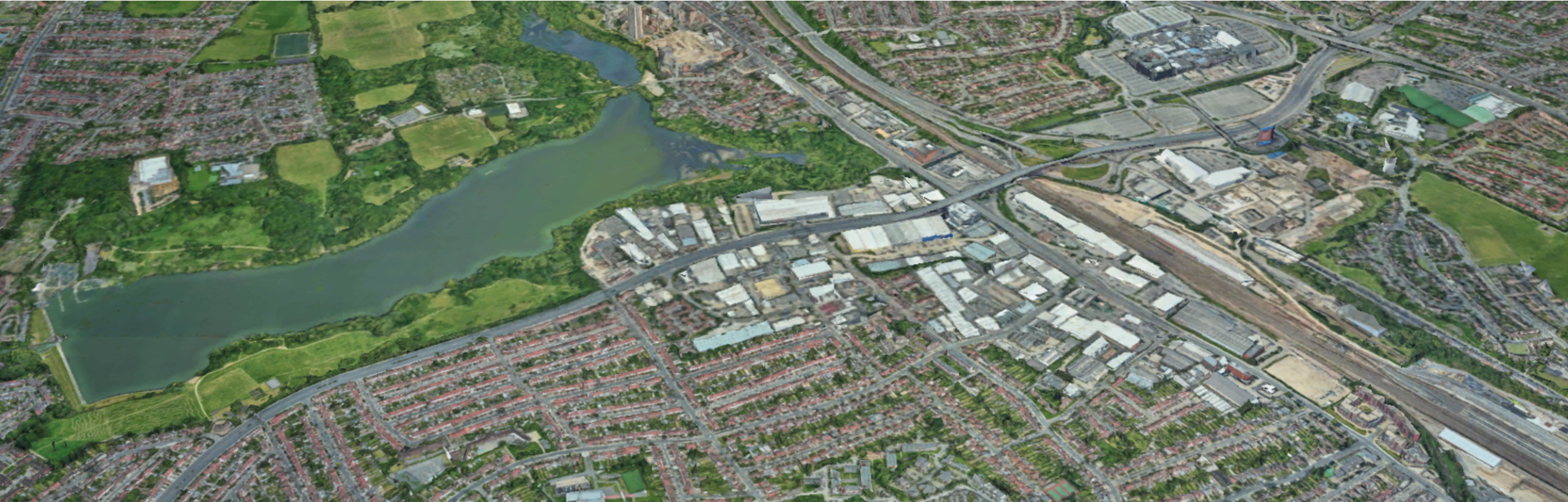
While there was relative peace and quiet for the
bird nesting grounds at the eastern end of the reservoir, there were major
developments taking place not far away, at Staples Corner. The narrow roadway
under the Victorian railway viaduct was causing major traffic problems on the
North Circular Road, especially when it was planned to start the M1 motorway
from here. A massive Brent Cross flyover was built in the 1960s, to carry
east-west through-traffic over the top of this bottleneck. You can see this in
the photo below, and I have added part of a 1921 image to help show the line of
the viaduct, which you can just see in the modern picture.
10. Staples Corner, with North Circular Road
flyover and the railway viaduct (including 1921 comparison).
You may be wondering what happened to the Welsh
Harp public house, which featured in Part 2 of this story. It had been replaced by a more
modern building in the 1930s (the fate of a number of historic inns in our
area), but it fell victim to more roadworks when the north-south A5 flyover was
built over Staples Corner in the 1970s. It was demolished in 1971, and its site
was where the north-bound slip road, from Staples Corner towards West Hendon,
passes the entrance to Priestley Way, a service road for a small industrial
estate. What a sad epitaph for the inn which gave the
Brent Reservoir its more popular name!
11. The 1930s Welsh Harp public house in
1971, and the site as it is now. (1971 photo by Geoffrey Hewlett)
Going back to the reservoir, this does have to be
drained occasionally, both for major maintenance work on the dam and to remove
the rubbish which unfortunately gets dumped in it. One remarkable feature when
this happens is that the original winding course of the River Brent can still
be seen, just as it was when it marked the boundary between Kingsbury and
Hendon parishes to the north, and Willesden parish to the south, when the land
was first flooded to create the reservoir in 1835.
12. The River Brent flowing through the
drained reservoir in 1974. (Photo by Leo Batten)
In 2012, responsibility for the reservoir was
passed to the Canal and River Trust, a charity set up when the Government
abolished the publicly-owned British Waterways Board. Questions were raised
about how safe the reservoir might be in the event of a severe storm, after a
similar Canal Age dam at Whaley Bridge in Derbyshire was in danger of collapse in 2019.
Luckily, it emerged that as well as regular checks, further reinforcement of
the dam with concrete had been carried out in 2005-07, following detailed
studies of how extreme heavy rainfall might affect the Welsh Harp reservoir,
and the river downstream of it. Brent Council also issued a statement following the Toddbrook Reservoir emergency, with
links to information for anyone who feels the need for reassurance.
Earlier, I mentioned facilities that had been set
up for young people near the reservoir. Sadly, Barnet Council closed the Youth
Sailing Base, which they inherited from Middlesex County Council, in 2004, and
sold off its site to a developer for building luxury waterside apartments.
Instructors from the Base went on to set up the Phoenix Canoe Club, so that
there is still a place on the Welsh Harp where youngsters can enjoy this sport.
13. Pond dipping at the Welsh Harp
Environmental Education Centre. (Photo courtesy of Harry Mackie)
The Welsh Harp Environmental Education Centre went
from strength to strength. Back in the 1980s, my daughters were among the
thousands of local school children each year who have enjoyed learning about
nature in a hands-on way, from enthusiastic experts. But the squeeze on local
authority spending has also hit the former cemetery site. By the 1990s, Brent
Council had closed its Parks Department nursery, which later reopened as the
private Greenhouse (now Birchen Grove) Garden Centre.
During the past ten years, cuts to funds allocated
to youth services first saw the WHEEC receive financial support from the Careys
construction group, then its threat of closure. Luckily this environmental
“jewel in the crown”, celebrated in a 2015 Council video, was saved when Brent
passed the Centre to the Thames 21 charity, under a Community Asset Transfer in
2016.
I hope you have enjoyed discovering more about “the
Welsh Harp” in this series of articles. With all Brent’s Libraries now open again (with restricted hours), you can
find even more information and pictures in Geoffrey Hewlett’s 2011 book, “Welsh
Harp Reservoir Through Time”, in the local history section at ref. 942.185.
14. The reservoir in 2010, and the cover of
Geoffrey Hewlett's book. (Photo: London Canal Museum)
But it’s also a place to visit and enjoy, on our
doorstep, if you can do so safely, whether for a walk, some wildlife watching
or perhaps to learn to sail or paddle a canoe. After all, it is (officially)
the Brent Reservoir!
Philip Grant
Next weekend we’ll take the No.32 northbound from the Priestley Way bus stop
(by the site of the Welsh Harp Inn) for a one-off special article, then ride the
same bus route southbound for a new local history series. Hop aboard “Wembley
Matters” to find out where these journeys will take us.
Thank you for joining me again, on this third stage
of our journey through the history of “the Welsh Harp” (our local reservoir –
not the musical instrument!). In Part 2, we saw how the enterprise of W.P. Warner
had made the name of his tavern synonymous with the reservoir beside it. This
time we’ll explore changes, on and around the reservoir, into the 20th
century.
1. The Kingsbury dam and its overflow,
c.1900. (Brent Archives online image 1341)
At first, not much changed. The area of water was
mainly surrounded by the meadows of local farms, and attracted visitors to the
countryside just beyond the expanding urban sprawl of London. Water flowing
over the dam to feed the River Brent was a popular sight, across the fields of
Gravel Pit Farm at Neasden. West Hendon had developed slightly, but there was
still lots of open space nearby.
2. Cool Oak Lane, with its causeway and
bridge across the reservoir's northern arm, c.1900. (Barnet Local
Studies Centre image 3284)
The Metropolitan Railway’s Neasden Works expanded, with a new power station to supply its
electric trains, which were introduced from 1905. The Canal Company, which
still owned the reservoir, refused to let the Metropolitan use water from its
Feeder for cooling purposes, so they had to sink two wells for that purpose. It
was the First World War that finally brought more industry to the area.
The airfield at Hendon already had a small aircraft
factory, run by the Grahame-White company, when the war broke out in 1914.
Other companies making planes for the rapidly developing aerial warfare were
soon active in the area, such as the Aircraft Manufacturing Company (“Airco”) in Colindale and Kingsbury, Handley Page
in Cricklewood and later Hooper & Co in North Wembley. In 1917, Handley Page designed a prototype
seaplane, hoping to sell it to the Royal Navy, and their R200 was test-flown
from the Welsh Harp. They did not receive an order, so
the seaplane never went into production.
3. Scale drawings of the Handley Page R200
seaplane. (Courtesy of the R.A.F. Museum, Hendon)
By 1917, the slopes of Dollis Hill down to the
reservoir were also the home of the Mechanical Warfare Department. Its role was
to design and test tanks, for use to try and break the trench warfare stalemate
on the war’s western front. By 1918, one of the designs it was working on was a
modified version of the Mark IX tank, and on a misty morning in November 1918
the world’s first amphibious tank was tested on the Welsh Harp reservoir.
4. A Mark IX amphibious tank entering the
Welsh Harp, November 1918. (Image from the Tank Museum)
Earlier this year, a friend interested in military
history sent me a link to a short film that includes (at the end) footage of
this test. It had been used as part of a French article on First World War
tanks, and was described as a ‘Duck Tank being tested on the pond of Dolly
Hill’! This “top secret” Department remained at Dollis Hill until 1921, before
being moved to Hampshire. Its main buildings, surrounded by a high wall, were
in the Humber Road area. It is remembered in the street name, Tankridge Road,
and a section of the wall remains at Walton Close.
5. Remaining section of Mechanical Warfare
Department wall, Walton Close, Dollis Hill, c.2010.
6. Aerial view of the reservoir in 1919,
with West Hendon beneath the plane’s wing, and Dollis Hill beyond.
The local aircraft industry was badly hit when the
Government scrapped its contracts for planes once the war had ended. One
company at Hendon made use of the unwanted aircraft to offer pleasure flights
to paying customers. The photograph above appeared with an article on the
subject in “Flight” magazine, in June 1919, and shows a view across the
reservoir to Dollis Hill.
7. The railway viaduct, seen from the
Edgware Road bridge, 1921. (Barnet Local Studies Centre image 871)
The 19th century had seen first canals,
then railways, develop as important methods of transport. This scene from 1921,
of the Midland Railway viaduct crossing the eastern arm of the reservoir, was
soon to change dramatically as the rise of motor vehicles meant a need for
better roads. The North Circular Road was constructed during the 1920s to help
heavy commercial traffic avoid having to drive through Central London. Its
proposed route would take it just south of the Welsh Harp, and by 1926 this
section of the reservoir was filled in, and the River Brent put into a culvert,
so that the road could pass under the brick arches of the viaduct.
8. New housing at Dollis Hill, and over the
reservoir at Kingsbury, late 1920s. (Brent Archives image 570)
The construction of the North Circular Road opened
up the northern slopes of Dollis Hill for development, and by the late 1920s
new streets were appearing between Brook Road and Links Road. These can be seen
in the photograph above, together with what must be the start of the Post
Office Research Centre at the top of the hill. Across the reservoir, new
suburban homes were also being built in the Church Lane and Wood Lane areas of
Kingsbury. In 1928, Willesden Urban District Council bought 40 acres of land on
the Kingsbury side of the Welsh Harp, planning to use it as a cemetery, which
would lead to disputes that lasted until 1965!
The rapidly growing population at Neasden and
Dollis Hill prompted Willesden Council to open a recreation ground on their
side of the Welsh Harp. They also built a Neasden branch library, overlooking
it, at the corner of Aboyne Road and the North Circular, which opened in 1931.
In keeping with a growing fashion for open air activity, this had a reading
terrace at first floor level.
9. The reading terrace at Neasden Library,
1931. (Brent Archives online image 2926)
One of the open air activities which had grown in
popularity at the Welsh Harp during the 1920s was “sunbathing”, although it was
not popular with everyone. By 1930, there was growing opposition among local
residents to the visitors who came to the reservoir’s banks to bathe in the
nude. One man complained to the Council that, while walking home to the Edgware
Road from Old Kingsbury Church on a Sunday evening, they had come across ‘a
bunch of stark naked men…. Hardly a pleasant sight for a man to have to pass
with his wife!’
Matters came to a head one weekend in June 1930,
when 40 men and women of the Sun-Ray Club (‘some wore no clothes, others wore
slips or bathing drawers’) were confronted by a crowd of around 200 local
people. Despite the presence of four policemen, who told them that the
sunbathers were on private land, with permission from the owner, and that they
had no right to interfere, the crowd attacked the bathers and drove them away.
Kingsbury Council dealt with the issue in a more dignified way, when they
received a deputation (not a new idea) from the National Sun and Air
Association in May 1931, although they also decided against sunbathing!
10. Extract from the minutes of a Kingsbury
Urban District Council meeting on 6 May 1931. (Brent Archives)
On the reservoir itself, the Brent Sailing Club was
formed at the Old Welsh Harp Inn in 1930. A less tranquil use of the water also
began the same year, when the London Motor Boat Club held its first speedboat
racing event at the Welsh Harp. Larger speedboats were also used to give thrill
rides for paying customers, as shown in this newsreel film from 1932.
11. A motor boat race on the Welsh Harp
reservoir in 1937. (From the collection of the late Geoffrey Hewlett)
The 1931 speedboat racing season had celebrity
guests at its opening, the aviator Amy Johnson and actress Anna Neagle. Amy had lived at Roe
Green for nine months, before the solo flight to Australia that made her
famous, and then had a flat at Vernon Court in Hendon Way. By coincidence, it
was Anna Neagle who starred as Amy Johnson in a film about her life, after her
tragic death in 1941, while flying as a wartime pilot in the Air Transport
Auxiliary.
12. Anna Neagle and Amy Johnson at the Welsh
Harp, April 1931. (From: ‘Amy Johnson – Queen of the Air’)
The south-east corner of the reservoir saw rapid
industrial development along its main roads, and on the reclaimed land, in the
late 1920s and through the 1930s. One of the factories by the junction of the
North Circular and Edgware Roads made mattresses. The company was Staples, and
the busy corner was soon known by that name. The traffic lights here became
well-known for the jams that built up, as seen below in 1937.
13. Staples Corner in 1937, with the mattress
factory bottom left. (Barnet Local Studies Centre image 4920)
When war came again in 1939, Dollis
Hill again had a part to play. Secret underground bunkers were built for the
Admiralty at its Citadel office building, on the corner of the Edgware Road and
Oxgate Lane, and for the Cabinet at “Paddock”, beneath the Post Office Research
Station in Brook Road. It was rumoured that a flying boat was moored on the
Welsh Harp, ready to fly Churchill and other key leaders to safety from their
reserve War Room if necessary, but I have no proof for that story. It was the
research station that developed the first electronic computers, used at
Bletchley Park for code-breaking during the war, and Tommy Flowers, who led the
team that made them, is remembered by the modern street name, Flowers Close.
14.
The aftermath of the West Hendon bombing, February 1941. (Barnet Local Studies
Centre image 5105)
It was not those
key targets that were hit during the Welsh Harp’s worst bombing raids of the
Second World War. Early in 1941, Germany was testing new designs of
high-explosive bombs, and dropping a single bomb in a raid, so that its effects
could be seen afterwards. One of these exploded above the Ravenstone Road area
of West Hendon on the evening of 13 February 1941, flattening 40 homes, killing
more than 80 people and making around 1,500 homeless. At the opposite end of
the reservoir, a V2 rocket hit one end of Wykeham School in March 1945. Luckily
no children were there at the time, but seven people were killed in nearby
homes.
Just as it had during the First World War, the
reservoir played its part between 1939 and 1945. A Hendon Sea Training Corps
was formed in 1941, and its young volunteers learned some boating skills on the
Welsh Harp, as well as on land at a school in Algernon Road. Production at many
factories was changed, to produce equipment for the war effort. Hickman’s works
on the North Circular Road had been shopfitters, but by 1943 their carpenters
were building wooden landing craft, which were tested on the reservoir before
being handed over to the Royal Navy. LCAs were “Landing Craft, Assault”, which
carried a platoon of up to 36 soldiers, from ships around ten miles offshore,
onto the beaches of Normandy on D-Day.
15. The Hickman's workers aboard a completed
landing craft, 1943/44. (Image shared by the son of a worker)
Next weekend we’ll visit the Welsh Harp in more
peaceful times. I hope you will join me then, for the final part of this
series.